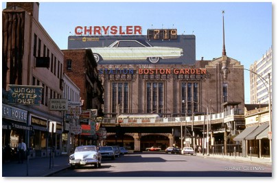
Looking north up Canal Street to the old Boston Garden. Photo by Dave Gelinas
Most people think of Canal Street when they are going to a game or an event at the TD Garden. Bars and restaurants catering to these crowds line the west side of the street.
No one wonders why it’s called Canal Street when the nearest water is not a canal but the Charles River on the other side of “The Gahdin.”
Canal Street and the Middlesex Canal
The answer is simple: the street once ran alongside an actual canal. The Middlesex Canal, created from 1794 to 1803, was a 27-mile waterway that was for 50 years critical to the industrialization of the Merrimack Valley. It originally ran from Chelmsford to Charlestown’s Mill Pond and increased greatly the amount and weight of products that could be taken to market. A canal barge could haul 30 tons faster than a wagon and a team of oxen could haul about three tons.
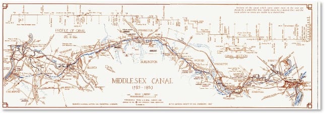
The path of the Middlesex Canal
Chief Engineer Loammi Baldwin first diverted water from the Concord River into the canal in December of 1800, and by 1803 the canal was filled all the way to Charlestown. The first boat operated on part of the canal on April 22, 1802. The barges were poled, rowed, and sailed downstream. Horses walking along towpaths pulled the barges back upstream.
Building Boston
Barges carried loads that included iron ore, timber, ashes, butter, cheese, beef, pork, cider and grains, along with tree trunks and bark for tanning. Back upstream went foreign-manufactured goods, groceries, codfish, mackerel, salt, lime and plaster. Some of Boston’s nineteenth-century granite buildings used stone brought into the city on the canal.
Architect Charles Bulfinch used ‘Chelmsford granite’ for the state prison in Charlestown in 1804. Harvard’s University Hall, the Massachusetts Bank on State Street, the Middlesex County Jail in Cambridge, Massachusetts General Hospital, also used Chelmsford granite, among others. Alexander Parris designed Quincy Market with Chelmsford granite.
Trees and Tourists
The canal made Boston the hub for raw cotton and other materials going to the textile mills of Lawrence and Lowell, as well as finished textiles shipped back from what was then the nation’s largest industrial city.
The barges also pulled tourists and vacationers on an early version of today’s river cruises. A slow journey along the canal made for a refreshing diversion from the hot city streets.
The MIddlesex Canal: A Major Engineering Feat
The Middlesex Canal was a major engineering feat that inspired the construction of other canals around the country in the nineteenth century, Including the Union Canal in Pennsylvania and New York’s Erie Canal.
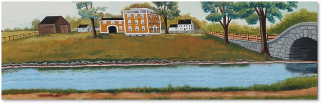
Painting by Thomas Dahill
The story of how the Middlesex Canal was created, starting with the signing of the Middlesex Canal Corporation charter on June 22, 1793, is a fascinating one. Shareholders included Governor John Hancock, John Adams, John Quincy Adams and Christopher Gore.
That story is too long for this post, however, which focuses on a single street in a part of Boston called the Bulfinch Triangle.
Middlesex Canal Shipping
Canal boats could carry heavy loads from the Middlesex Canal’s southern terminus in Charlestown across the Charles River and through an extension in the Mill Pond, which was then being filled. That extension, which ran through the middle of the Mill Pond, was considered a part of the Middlesex Canal.
Canal Street trolley looking toward North Station
Barges went from Boston Harbor north through the old Mill Creek, into the Mill Pond, then entered the Charles River. From the Almshouse Wharf in the West End they were drawn across the river on a series of buoyed cables that formed a kind of floating towpath. At that point, they entered the canal, which was located near what is now Sullivan Square.
NOTE: Farmers from up north sent their hay down the Middlesex Canal to feed city horses. It was sold in, of course, Haymarket Square.
The Canal Extension
The city eventually filled in the Mill Pond on either side of the canal extension, starting with the west side. The canal was set below street level and Canal Street ran alongside it. The railroad companies later used the surveyor’s maps created for the canal to build the tracks that carried the trains that eventually put the canal out of business. While a barge could haul 30 tons, a train could carry 300. The changing technology led to an exponential growth in shipping goods.
The Middlesex Canal’s extension down the center of the Mill Pond that had been left open was filled in during the summer of 1844 to make land for Boston and Maine Railroad tracks.
Thus, Canal Street takes its name from the old canal extension. (A “matching” Canal Street was laid out on made land in Charlestown on the section of Rutherford Avenue between Sullivan Square and Middlesex Street.)
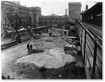
While no sign of the Middlesex Canal remains on the surface of Canal Street today, portions of the canal wall, built to specifications, were found when the elevated MBTA line was being constructed in 1908 on the site.
Canal Street Today
Today, the Bulfinch Triangle, the section of Boston that was built over the old Mill Pond and the canal extension, has become a trendy and upscale neighborhood. New residential buildings, a hotel, and restaurants have replaced the Mill Pond, the canal, and the railroad.
And while those fans in their Celtics and Bruins jerseys have never heard of it, you can find information on the Middlesex Canal in several locations:
- The Middlesex Canal Museum and Visitor Center: Located at the Faulkner Mill in North Billerica.
- Lowell National Historical Park: Your tour can include a boat ride on the old canal.
- The Middlesex Canal Association: This website is filled with information, including walks, bike tours, and other events.
- One Canal Apartments : This luxury apartment building has a mini-museum in the lobby that includes a large illustrated map of the canal’s route on the wall, blocks of granite and plaques with information about the products the canal carried. Before the pandemic, you could pop in and check it out. I don’t know what the situation is now.
- “The Middlesex Canal: New England’s Incredible Ditch”: A fascinating article from the New England Historical Society.
- “The Middlesex Canal” by the Harvard Mathematics Department: A narrated history of the canal with illustrations ranging from period paintings to a Google Flight Simulator fly-over.
- There used to be a small store-front museum on Canal Street but I don’t know if that has survived the pandemic.
The Remains Abide
You can also find sections of the old Middlesex Canal, including some of the 50 bridges, eight aqueducts and 20 locks, still extant along its length. The Concord River today shows the effects of the dams built to flood the canal. Some of those flooded meadows now belong to the Great Meadows National Wildlife Refuge as wetlands.
If you want to find a place near you, head up to the Museum and Visitor Center, which offers a wealth of information. BTW: The 27-mile path of the canal would make a great marathon route.

A water meadow at the Great Meadows National Wildlife Refuge