Some of Boston’s most interesting landmarks are tucked away in places that are hard to find and not well marked. As spring is coming (I hope) I have been thinking about Spring Lane—how it got its name from the Great Spring and why it was important.
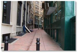
Spring Lane is a dark crooked alley that connects Washington Street (then called Cornhill Street) with Devonshire Street. Its narrow width is typical of what Boston’s streets, or lanes, looked like in the seventeenth century.
About halfway down the path, which is sandwiched between and shaded by modern buildings, you will find plaques that tell us Spring Lane was at one time a most important street—and probably the reason Boston began as a city on the Shawmut Peninsula.
It Was All About the Water
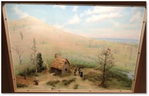
When the Puritans sailed into Boston Harbor 1630 under the leadership of John Winthrop, they set foot first in what is now Charlestown. This area had only brackish water, however, which made it unsuitable for building a town. “Bad water” from a single spring located near the tide line took the blame for an epidemic of sickness that broke out among the 1100 settlers.
Fortunately John Winthrop encountered Rev. William Blaxton, or Blackstone, an English immigrant who had arrived in Plymouth in 1623 and migrated to Boston. He lived alone on the western slope of Beacon Hill near today’s Louisburg Square.
Rev. Blaxton told them the Shawmut Peninsula had excellent water and offered to share it with them. In fact, the Indian name “Shawmut” supposedly means, “land of living waters.”
This clean and abundant water was so important that Winthrop’s Puritans not only crossed the Mystic River and relocated on the Shawmut Peninsula, they built their settlement around it.
Their early village occupied the land now bounded by Milk, Bromfield, Tremont and Hanover Streets. Reinforcing the spring’s importance is the parallel street on the other side of the Winthrop-Carter Building, which is called Water Street. The first public buildings went up nearby and both the Old State House and King’s Chapel, site of the first burying ground in Boston, can be reached in a short walk from the Great Spring.
Where Did the Water Come From?
Geology provided the Shawmut Peninsula’s abundance of fresh potable water. Clifford Kaye explains how it works in his Geological Survey Bulletin: “The Geology and Early History of the Boston Area of Massachusetts, a Bicentennial Approach.”
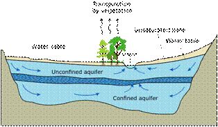
“Most of the area is underlain by a sandwich of thick highly pervious gravels between till and clay; this sequence has been deformed and folded upward to form Beacon Hill. Rainwater seeps into the ground and fills up the network of tiny voids that always exist between pebbles, grains of sand and even microscopic particles.
“Gravel and coarse sands, which have a network of large intergranular spaces, filled with water readily yield this water in wells. This coarsely porous earth material is called an aquifer. Fine sands, silts and clays, on the other hand, are not aquifers because water cannot readily flow through the network of capillary-size pores. This type of earth material does not yield water in a well and is called an aquiclude. When the two types of sediment are interlayered, that is if an aquifer is sandwiched between two aquicludes, the system is then comparable to a pipe, the aquicludes effectively forming the walls of the pipe.
“One can understand the mechanisms of an artesian well (a flowing well) by comparing such a system with an inclined or vertical pipe filled with water. If a hole is punched in the lower end of such a pipe, water will escape, squirting out as a jet, the height of which depends on the height of water in the pipe (the hydraulic head). Water rises in wells or bubble up out of the ground in flowing springs for the same reason—the hydraulic head in the aquifer.”
So the abundant glacial gravel, sand and clay that underlies much of Boston combined with rainwater to create the Great Spring.
The Great Spring: Covered Over and Ignored
The old spring, sweet and reliable, provided water to the citizens of Boston for 200 years. Other springs, shallow wells and cisterns supplemented its output as the population grew until a municipal water system took over in 1848.
The Great Spring was covered up, uncovered again in the nineteenth century and then paved over. Thus Boston’s original source of fresh water—the single most important resource for the city’s founding fathers—simply disappeared. Although one could say Boston was born on Spring Lane, the commuters hurrying along it to and from work have no clue as to the historical importance of the Great Spring.
Dueling Plaques
The City of Boston, which is often clueless about marking important sites, has placed one of its small and easily overlooked plaques on the Winthrop-Carter Building. For folks who stop to read it, the inscription tells us:
“The excellent spring water on the Shawmut Peninsula drew the Puritans to settle here. The site of the spring is marked on Spring Lane. Nearby the colonists built their compact town. The first church, first market, first prison, first burying ground, and the house of the first governor all stood close together. Today, two major landmarks, the Old State House and King’s Chapel, stood on the edges of the site of the early town center.”
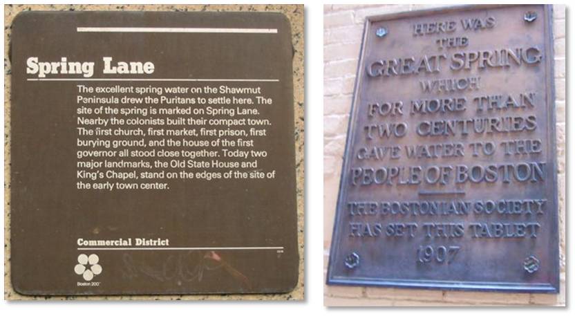 A larger bronze plaque put there privately by the Bostonian Society in 1907 says simply:
“Here was the Great Spring which for more than two centuries gave water to the people of Boston.”
Directions to Spring Lane
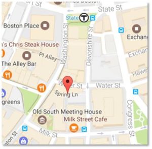 You can find Spring Lane quite easily by approaching it either from the Washington Street (uphill) side or the Devonshire Street (downhill) end. The MBTA’s State Street station gives the most direct access because one entrance is actually part of the Winthrop-Carter Building at Devonshire. The Government Center and Park Street stations are also just a short walk away.
Aside from private garages, both the Boston Common Garage and the Government Center Garage let you park nearby.
If you visit during the week, try to avoid rush hour when commuters hurry down (or up) Spring Lane like water in a pipe.

Another relevant plaque concerns the only Plymouth Pilgrim who moved to Boston from Plymouth: Mary Chilton. She may have been the first English woman (age 13) to walk on American soil. She became an orphan in 1621 when her mother died. Her father, James Chilton, signed the Mayflower Compact, but died days later in Provincetown harbor. Because Mary came on the Mayflower, she was given 3 portions of land in 1623 and applicable shares of cows in 1627 when the community property divisions were made. A nice dowry for a young orphan. She eventually married John Winslow and they moved to Boston where they lived on Spring Lane. The house is no longer there, but the reminder is a nice bronze plaque. She and John have a tombstone in the King’s Chapel Cemetery as well as a prominent mention on the entrance plaque and a description in the cemetery.
Fascinating! Thank you for sending this, Susan.
Is the spring under Spring Lane still there although covered up? I am a Freedom Trail tour guide and am asked this question often.
Yes it is still there but covered. I wish we could see it. That would be a nice link to history.
Thanks for this history of Rev. Blaxton’s spring. I am a volunteer at the Metropolitan Waterworks Museum (Chestnut Hill Reservoir) and I first heard of this spring from Marcus Kemp, who gave a orientation presentation to new volunteers.
Let’s arrange a private tour of the Waterworks Museum for Boston By Foot docents. We’re all volunteers and well versed in Boston history. I’m sure many people would enjoy such a tour.