Boston has the oldest public park in the country (Boston Common) and a beautifully landscaped string of parks (the Emerald Necklace), but it also includes smaller parks tucked here and there. Ashburton Park, which crowns the top of Beacon Hill, holds the distinction of being placed on what was formerly an overlook, yet is itself often overlooked.
This small park gets little attention in Boston guide books and is another place that people mostly pass by and go through on their way to somewhere else. In fact, most books and websites refer to it simply as a way to get into the Massachusetts State House. It deserves more respect for several reasons.
As always in Boston, we need to start with some history to set the stage. It will take a least two posts to get to the point. Stay with me, now.
Beacon Hill and the Trimountain
Beacon Hill is, of course, the third and tallest of the three peaks that lay along a ridge toward the center of the Shawmut Peninsula that formed as glacial drumlins. All three had different names at various times but together were known as the Trimountain. This gave its name to Tremont Street. Eventually they became known as Pemberton Hill, Beacon Hill, and Mount Vernon.

“The Trimount” by Caleb Snow
Originally named Sentry Hill, the tallest of the three peaks stood somewhere between 138 and 151 feet above sea level. It thus offered the new settlers the best vantage point from which guards could stand watch for unfriendly ships entering the harbor.
Five years after settling the Shawmut Peninsula in 1630, the
The General Court proclaimed that,
“… there shall be forthwith a beacon sett on the centry hill at Boston, to give notice to the country of any danger.”
The Beacon
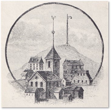
Original King’s Chapel with signal beacon in background
In response, they raised a structure to hold a cauldron of flammable substances that could be lit in time of danger. It stood for 150 years and can be found in early maps and drawings of the city.
Described as a tall pole supported by triangular braces, the beacon supported an iron pot of combustible material. The pole held rungs for a watchman to climb up and light the beacon. (Using what, I wonder. Flint and steel? A torch? A cinder in a pot?)
In all that time, the structure most likely weathered and deteriorated and needed to be replaced, which explains why it looks different in some historical images.the one above shows the original King’s Chapel with the beacon standing on Sentry Hill in the background.
Was the beacon ever lit? We have no record of that occurring, which speaks to a peaceful part of Boston’s history.
Beacon Hill’s Lofty Summit
At that time, the summit rose about 60 feet higher than it is now. Because Beacon Hill was tall and steep, the settlers found it unsuitable for building houses or farming. They used it only for pastureland. This description from “Beacon Hill: a Living Portrait,”* gives you an idea of what climbing it was like:
“A lane named Sentry Street led from the Common to the beacon, which was only attained by a strenuous climb, with the aid of toe holds worn in the slope.”
Once there, a visitor found him/herself on a grassy dome with a flat top of some “six rods square,” or 99 feet on each side. The view from the top would have made the climb worthwhile, turning this small overlook into a popular place.
The Carving Up of Beacon Hill
That all began to change in the early part of the 19th century as Boston pursued its centuries-long project of making land on and around the Shawmut Peninsula. By 1810, the heirs of John Hancock, who owned most of the land, had started cutting into the peak and carting away the dirt to sell it as fill.
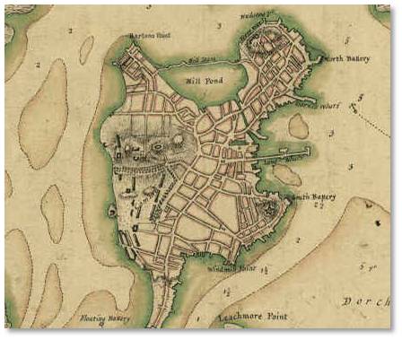
Map of Shawmut Peninsula in 1775
In 1811, the town sold its lot, long considered public land, to the Hancock heirs. This industrious group continued digging, carrying away, and selling the summit of Beacon Hill. Where did it go? The top of Beacon Hill went into filling the Mill Pond, creating land now known as the Bulfinch Triangle.
That means, if you are walking down Canal Street on your way to the TD Garden for a Celtics game, you are walking across the top of Beacon Hill. Who’d a thunk it?
This carving up of the hill flattened the peak, creating 50 acres of new land—on part of which Ashburton Park would later be constructed.
Bibliography
There is more to this story than I can fit into a single blog post. For more information, I suggest the following books:
- *”Beacon Hill: A Living Portrait” — Barbara W. Moore and Gail Weesner
- “Boston: A Topographical History” — Walter Muir Whitehill
- “Gaining Ground: A History of Landmaking in Boston” — Nancy Seasholes
- “An Illustrated History of Ashburton Park” — Mass.gov
More will come soon in Part II of this post.